The plan is to cycle around the Coast of Britain setting off in April 2010. The journey is around 4300 miles. I'm cycling unsupported - no van to carry the goodies, so I'm shopping around for the lightest kit that will do the job. In this blog I'll review the kit as I pick it up for the trip and blogging daily once underway.
The NordicTrack GXR 4.2 I bought features a technology they call iFit. I've found this feature so special that I thought it worth writing about separately. The tech consists of a compatible piece of exercise equipment, a plug-in wifi module (at least on the level of equipment I'm looking at), and a web-based application.
The basic functionality allows the selection of a training session on the website, this is downloaded to the bike (it's also available on treadmills, etc), and then the user rides the session. The 'party trick' is that this session can be a 'real world' route. The session data is downloaded to the bike and the bike adjusts the riding resistance during the session to simulate the climbs and descents of the real world route. Whilst you are riding the route an internet connected device (laptop, tablet, computer) connected to the iFit site can show StreetView images of the route as you ride, sychronised to the speed you're riding...
The video below shows a simple Asus 7in tablet sitting on the console of the bike and showing the route (Central London) as I ride:
As you can see, it's a little more 'flick book' rather than full motion movie, but I'm finding it great entertainment riding routes in cities and locations that I'd otherwise never visit. It isn't unusual to for a route to have a little 'looking around' as this one does at the start but most every session I've used settles down and shows the road route. Sometimes it does show 'travelling against the traffic flow' which is disconcerting but I guess is either a problem with the route definition or simply a limitation of the available photographs in the Google StreetView database.
There is another class of iFit exercise sessions that don't have the StreetView feature, but the do follow a planned distance/time/gradient profile. And some even have trainer voiceovers to add encouragement to a session.
There are many collections of StreetView routes and/or videoless exerises sessions available on the iFit site. Some are free, others have a fee.
The final magic trick is that you can simply (and I've tried and it really is simple!) create your own exercise sessions by plotting a route on Google Maps via the iFit site. I did exactly that for a Christmas Day ride along the Craignure to Tobermory road, over looking the Sound of Mull. It just worked. Although the gradients were a bit of a shock at times!!!
So how well does it work?
To be honest, surprisingly well! The refresh speed of the StreetView images could, perhaps, be a little faster, but on many sessions I've forgotten it's a 'flip book' I'm watching. I guess because of the update rate and two-way data transfer across the internet the bike levels off 'at the top of the hill' but the images are still one or two off that location. Not really a problem, just a little disconcerting the first time it happens. It does provide a significantly more engaging view than just watching a 30 minute timer count down!
After riding a session your statistics are available to view back on the iFit site along with other riders who've previously ridden the route. I'm finding pushing my stats against others is increasingly becoming my motivation on some of the rides!
The whole system is occassionally a little clunky and has a little bit of a work-in-progress feel to it. Indeed, I've spotted problems, reported them and seen them fixed. It is reassuring that the application is under active development/improvement.
iFit membership for the first year is included with the purchase of the plug-in wifi unit, and with a little careful shopping that unit is sometimes included with a piece of exercise equipment - as was the case with my GXR 4.2. I'm sufficiently impressed both with the tech keeping me motivated and the results from having used the bike over the winter that I'll be renewing the membership when it becomes due.
I'm also sufficiently impressed the tech that I'm planning on adding an iFit-equipped treadmill to my home gym.
UPDATE (16th February 2014): All is fixed and working!!! I'll post a new review and an iFit review shortly... After banging my head against what appeared to be the usual menu-card-driven first-line type of customer support that many for a couple of months I got through to the-man-who-can! The first line guys had suggested swapping parts to be fair, but without success and we'd clearly go to the end of their ability. So after causing a little bit of fuss I got through to the next level of support and, after some initial investigation it was agreed my machine was faulty, then the same fault was identified on a stock version of the bike! More investigation and a surprisingly simple fix - a simple sensor repositioning within the machine has cured everything!!! Two sensors next to each other were interfering, moved apart they behave..... Easy!
---===oooOOOooo===---
I don't have a local night ride route that isn't car-infested so during the weekday winter evenings I don't usually get any exercise in. I've noticed my weight increasing and it's getting harder and harder to shift it. So this winter I had a plan! Early on I bought a rowing machine and at the start of December, I added a high-end exercise bike to the 'stable'. Since then I've been doing more-or-less 30 minutes on each machine each evening. And it's working - I'm down 7.5kg (16.5pounds) from my peak last Autumn.
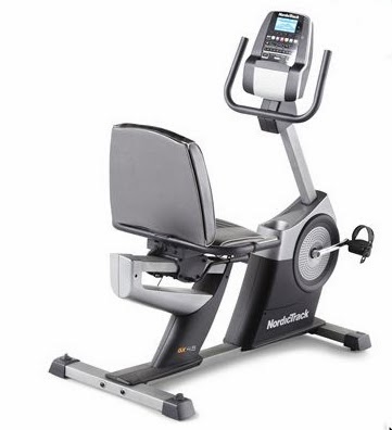
As I only ride recumbent I didn't really want to go upright for a stationary bike so I went for the NordicTrack GXR4.2. With a 9kg flywheel, 22 resistance settings and the ability to use standard road bike pedals and shoes it seemed a well balanced specification. It's a bit of a beast but that does at least mean it doesn't move in use!
The Good - the iFit feature has been amazing - I'm that impressed I'll do another post covering it in more detail. Basically it lets you plot a route on Google Maps, download the ride profile to the bike, ride the route with the resistance relatively realistically varying and, with the addition of a tablet computer, you get almost-realtime StreetView images of the route. More in a later post.
The Bad - the promised heart rate feature appears to be fake!
The Ugly - customer support, after initially swapping out parts, is now telling me that what I've got is as they intended and tough luck....
So... the full story...
I bought the machine from online retailer Sweatband, who were great - machine ordered, next day delivery. Couldn't have been better. The Courier separated the two parcels during shipping; the machine and the iFit plug-in hardware, but as it took an evening to get the machine assembled and working this was no problem.
So, up and running, the bike comes with heart rate sensor handles. I've used these in the gym so had no worries about them. But on this bike they just don't work. The instructions said to hold the handles for 15 seconds to give it time for the reading to settle. I've been doing 30 minute training rides and have tried hands on the handles for the duration. The problem is no matter what I've done the heart rate displayed on the screen is always just 10x the current speed! I could make that same guess myself without having a display for the purpose!!!
The manual instructed that in the case of any queries/questions/problems to go direct to Icon, the European distributor. They supplied a Polar chest strap - removing the need to hold the handles. The result - no change - the displayed pulse rate is still ALWAYS 10x the current speed...!
The iFit equipment logs data - here is a 30 minute log of speed and heart rate. Now I'd kind of roughly expect heart rate to pick up from rest over a few minutes and then kind of track effort, but as this graph clearly shows - heart rate is almost exactly 1-to-1 tracking speed... The session is steady rate effort - the speed variation is purely from me as I've adjusted my position, got tired, realised I'm slowing, etc.
Next Icon suggested replacing the Console - the main computer. They suggested this on 23rd December and, what with the holiday disruption, the replacement arrived on the 20th January. The results are the same...
This week I've invested in a Garmin heart rate strap and have made a video showing the GXR display and the Garmin side-by-side.
The video shows the pulse rate on the GXR (the figure in the lower centre of the blue screen, keeps alternating with calories display):
* The two readings more or less agreeing at the start.
* As I accelerate the GXR shows pulse tracking speed - immediately jumping from 122 to 141 when speed increases from 12 to 14mph whereas the Garmin takes time to climb up to 120bpm.
* This is repeated for 16mph - and a jump to 160bpm on the GXR.
* And again for 19mph - 197bpm on the GXR with the Garmin still at 144bpm - A VERY significant error.
* A demonstration of deliberately putting the pulse rate at 145bpm is then achieved by simply accelerating to 14mph.
Further testing at different resistance settings shows this 10x speed relationship to remain constant - so even when the machine is set to simulate a hard 12% hillclimb and I manage to maintain a 12mph speed (working very hard), the display 'claims' a low pulse rate of 120bpm where as I'm actually pretty much at my limit.
The GXR is clearly 'Guessing' the pulse rate based on speed - it is not using any sensors at all despite the manufacturer's claim - and the displayed figure is so inaccurate it makes a farce of the manufacturer's claim of being able to use the reading to keep within heart rate training bands.
I've now received emails from both Icon and from NordicTrack themselves 'explaining' this behaviour...
Icon: "The heart rate monitor is not a medical device. Various factors, including the user’s movement, may affect the accuracy of heart rate readings. The heart rate monitor is intended only as an exercise aid in determining heart rate trends in general."
NordicTrack: "For the most accurate heart rate reading, please stop pedaling, then hold the contacts for at least 15 seconds. Are you doing so? If not, please do so. You may even want to take three consecutive readings and take the average so as to ensure accuracy. Also the sensors seem to work best when the palms are dry"
I've NEVER encountered any gym equipment that requires the user to stop for the best part of a minute to take their pulse to ensure they're training within their target band - and I'm pretty sure by the third reading my pulse rate will be heading rapidly back toward my resting pulse rate!!!
And this advice is despite the machine 'guessing' my heart rate without me even needing to touch the sensors or wear the chest strap!
This is clearly a dangerous situation - with the machine significantly over reading I'm able to exercise under the impression I'm preparing myself for a much higher work rate than I'm actually achieving. Planning real world activity based on this information and overexerting myself believing I'm sufficiently trained could have serious consequences.
Basically NordicTrack appear to have behaved fraudulently as I have demonstrated above that the equipment I have simply does NOT even attempt to read the user's heart rate. I have not yet been able to establish if this is due to this example of their equipment being faulty, or if the GXR4.2 series machines don't work as advertised.
I intend to offer NordicTrack/Icon the opportunity to comment on this blog and, if the issue can't be addressed, I will refer the matter to Trading Standards.
This time at least Kate lasted the trip... but there have been a few minor repairs to make. After the rough track down to YHA Tintagel it isn't a surprise that some of the stick-on carbon-kevlar patches that I use on Kate's delicate lower reaches needed renewing. This material often looks like it has had a hard time and is badly damaged, but, on removing it, it is often just the soft glossy surface that is damaged and the 'working' layer of carbon-kevlar is just dirty with no damage to the gelcoat below. I guess this means the stuff is doing it's job and the small cost of renewal just means that it is ready for next time.
The ongoing problem of Kate's rear wheelbox needed attention. I've reglued parts of this before but there were a couple of lose sections - the ends closest to the axle entry hole. I've both glued-and-screwed this time - both to clamp the epoxy and to provide secondary mechanical fastening. Hopefully these will stay attached this time.
It doesn't seem to be a real problem but when the wheel box join starts to separate there is a lot more vibration noise from the rear of the bike. The 8mm dome nuts aren't pretty but seem a relatively tidy and light weight solution to the problem. Looks like I forgot to clean down the greasy marks after remounting the back wheel too...
The only other gear problem I had was with the Nemo Zor sleeping mat...
On the 2nd night I woke in the morning to find the mat a bit soft. On pitching at the end of the day it wouldn't inflate and I found a hole just little towards the centreline of the mat from the dark part of the label. I'm pretty meticulous about what-goes-where in my tent so haven't had anything sharper than the zipper of my down bag against the mat. To add to the disappointment, on opening the 'repair kit' that comes with the mat, what I'd thought was a self-adhesive repair patch was just a circle of colour-matched fabric - supply your own glue. The only glue I had was from my tyre repair kit which, obviously(!), was as effective as water on this material. I used the uninflated mat as a protective layer under my bag for the rest of the trip and that's on my repair list before next time.
I've never experienced this problem with the Thermarest mats and to experience it so soon on the Zor is disappointing. I'm now torn between repairing and hoping for the best or returning to the slightly heavier but previously reliable Prolite 3. Either way I guess I need to work out the correct glue for a repair first as I'm sure that won't be covered under any guarentee.
My Garmin Edge 500 doesn't seem to have survived the trip either - it refuses to connect to a computer to upload all the 'trapped miles' I've stored in it. That seems to be the only problem as it charges just fine and still works as a speedometer. I've probed the depths of the menu system to recover the summary data recorded in this blog. I've tried all of the published 'reset' incantations without them fixing the problem - including one which seemed to achieve a 'factory reset' but despite the warnings, didn't delete the data on the device. I bought this unit in 2010 so perhaps it owes me nothing and its time to move on.
On the upside, the Aeropress coffee thing worked fine and was worth the bulk as a luxury item for that first coffee of the day.
Planned as a 'short' day as I was meeting up with Carol in Bude for the drive home I was unsure how long to allow for the 20 mile ride. Cornwall had taught me that 20 miles could be an hour, it could be 10... Ok, so unlikely to be that long, but half of it could have been 2mph climbing...
And that is how the day began - with the steep and rough stone path away from the Tintagel Youth Hostel...
The rough climb back up from the Youth Hostel
YHA Tintagel - parting shot
After regaining tarmac I headed for Boscastle. There was no sign of an open cafe for breakfast. Heading away from town on a brisk climb a local helpfully called out "We call this Mile Hill...". Hmmm... felt like more than a mile to me. But there was a reward in the form of the excellent cafe at the Boscastle Farm Shop. But don't bother looking for it on StreetView or Google maps - it is THAT new - lucky me otherwise it would have been a long time until breakfast.
The cafe has a rule that it's a minimum of £10 spend to pay by card, so after a pot of excellent Cornish Tea and a hearty breakfast I just had to finish it off with a nice, strong coffee...
Refreshed the rest of the climb up to the A39 didn't seem too bad. With time enough before the lunchtime rendezvous I took NCN3 rather than the main road dash into Bude. I mean, if they're good enough to signpost it as a cycleroute it should be nicer riding than the A-road, right?
Well it started out well enough. There was the start of the Cornish Hedged Roads that people had warned me were typical of Cornwall but that I didn't encounter until 10 miles from Bude - almost the end of Cornwall... And then there was Millbrook... I cautiously edged Kate down the 30%, stopped on the apex to perform a manual turn for fear of rolling on the inside line which seemed somewhat steeper than the claim - and almost that in the camber too. The reward for the careful descent...?
The Vicious Descent into Millbrook (apologies for dodgy photoshop image merge - I couldn't stand far enough back to fit it in one shot!)
Yup - it goes back up at 30% on the other side!!!
Yes, it is that steep, both down and then back up...
And just in case, here's the StreetView link. My suspicion is that this is a "cycle route" because they consider it to be too steep to be a "scenic drive" route!
After that the ride up across Widemouth Bay and down into Bude was relatively easy!
Specs: 21 miles, 620m/2030ft of climb, 7.9mph average speed.
Today started wet and miserable. The tent went away damp from the fog but I arrived in Perranporth in the rain. I scouted around for an open cafe to hide in for breakfast but the owner of the only one I found anyone in indicated he didn't open for another hour. I did find the Co-op and a cashpoint before heading off in the drizzle.
The weather improved as I picked up the main road into Newquay. After a couple of attempts to navigate the somewhat odd one-way system (arriving at the same roundabout twice - via different routes) I found the main shopping street and Tea and a Hot Breakfast.
Onwards and it was a bit of a dive downhill into Watergate Bay - it wasn't entirely clear which road was the way out. It took a three-point turn in the car park to point in the right direction for the tight corner but gentler climb away from the beach. At Mawganporth I treated myself to both an ice cream and a new map - my road atlas now being so wet the pages were beginning to disintegrate as I tried to turn them.
On the outskirts of Padstow the route turned south and was actually flat for some time! The flattest road I'd encountered for several days. To cut around the estuary the shortest route was to join the A39 for a while. A pretty busy road but I only needed a short stretch before picking up the next section of coastal B-road. It did make quite a change to be able to let rip on the downhill towards the bridge over the River Camel but I paid for that on the drag up to the roundabout and my turn north away from Wadebridge.
This section was initially quite busy but as seems to be the way with these rural B-roads everybody else gradually turned off leaving me to more quiet riding. At St Endellion I pulled into the Trevathan Farm Tea Room. It was time for a much needed (and very generous - I must have looked like I needed it!) slice of chocolate cake and several cups of tea. That was enough fuel to get to the target destination of the day.
For a treat on the last night of this leg of the trip I decided I'd earnt the reward of sleeping indoors. Rolling towards Tintagel I was pleased to find the Youth Hostel to be well signed. Taking the turn the road reduced in size. Then in quality. The final stretch down to the hostel being little more than a stone track. On the final bend rather than risk rolling I got out and made a manual turn... Kate grounded several times on this section - but then the warden reported so had his car...!
Kate at YHA Tintagel
Looking SouthWest from the hostel
Tintagel is one of the possible claimed locations for the legendary Camelot and certainly walking over the rise from the Youth Hostel to the pub it is rather magical when the 'island' where the castle once was rather spectacularly pops into into view.
Camelot or not?
The modern 'drawbridge'
Onwards to the village and the pub
Dinner and a beer at Ye Olde Malthouse Inn (14th century) was very welcome and felt well deserved. No sooner had I ordered than the staff began bringing in the food signs from outside - I was assured I'd not eaten the last food they had, they were just short of staff so the kitchen was closing for the night - a close shave and nearly plain pasta for tea!
Also closing was the castle, so no opportunity for a visit this time. So time to head back to a warm, dry bed for the night.
Heading 'home' for bed - the village church with a rather oddly shaped tower.
Specs: 54 miles, 1348m/4376ft of climb, 8.8mph average speed.
A damp, foggy morning... Tent away wet again. Packed up and the mile or two down to Land's End for around 9am. Everything was still shut though apparently it is no problem just to wander on in...
Can you tell where I am yet?
Finding the route through the closed theme park and heading for the actual end of the land I found The Land's End Hotel. Parking up outside and asking at reception I was escorted to the bar where I bought a coffee and sat contemplating what the view would look like on a clear day. The waitress assured me she could make out the lighthouse in the fog but I didn't even have a clue which way I was supposed to be looking to find it... For any of you heading that way, rolling up as a damp cyclist didn't phase them one jot and the hotel certainly looked very classy and an excellent spot to blow the budget and stay the night at the end of a John O'Groats to Land's End ride. Surprisingly checking the prices they don't look too bad either...
Hunting around outside there was no sign of the famous signpost, just a notice saying that when it wasn't "in operation" to the other one at the other end of the patio - which wasn't there either. Ok, so I guess I saved myself the cost. And in the fog it would just have looked like it could have been anywhere. Another time...
I'd already made the decision, rather than take the fast LeJOG route along the A30 (potentially dangerous - ie. too many not-careful-enough drivers on what would be a rural A-road elsewhere in the country) to follow the coastal B-road north. This would mean more challenging riding but a better cycling experience and seeing more of the 'real' Cornwall.
Mid morning coffee and cake was at the Geevor Tin Mine cafe where the staff pronouced Kate as 'the unusual vehicle of the day'...
Travelling onwards the height increased, the surroundings becoming moorland. Picturesque dilapidated tin workings were all around... As the weather improved this whole section of coast kept revealing promising hints of pretty detours down to small villages. It would have been good to have the time to explore them all but I have miles to cover... I feel I need more words for this section - with improving weather and blue skies is was good, enjoyable riding that needs to be experienced rather than described.
The B-road remained quiet up to St Ives which is where everybody seemed to going to and from. With little choice on route I joined the busier route down into Hayle and a lunchtime cafe stop. Onwards, via Portreath. Taking the lesser road towards Porthowen the long drag was rewarded with a sudden and unexpected Tea Garden with the most wonderful Apple Crumble that was made with apples from the tree right next to the tables.
Clipping the edge of St Agnes and heading north the weather began to close in again and I was feeling the miles in my legs. Usually Day 3 is the challenging one so it seemed a little odd to be suffering today, but the turning weather wasn't helping. My GPS showed Cross Coombe Farm at Trevellas but arriving at the gate a sign indicated I was in the right place but there was no sign of any life or facilities. My first camp site failure. With a small 'public' touring site right next door I didn't bother poking around I went there instead.
Pitched, a good hot showered, coffee and caked, I took a gentle walk down the somewhat steep road to the beach...
Specs: 47 miles, 1018m/3340ft of climb, 9mph average speed.
I'm a cyclist currently hanging out with the lightweight backpacking crowd because they have the best lightweight camping kit that I need in order to keep down the weight of my cycle. The bike won't be ready until the end of the year so in the meantime
I'll be day-hiking and, hopefully, backpacking to put the rest of the kit through it's paces. Hopefully the guys won't notice I'm faking it on the walking front!


