Sunday, 6 October 2013

GAB 2013 Day 4: Tuesday September 24th - Veryan to Land's End

The weather... Late September is heading towards Autumn. Cornwall is the at extreme South and West of the UK. The week before this trip had been wet and windy but fortunately for this week the forecast was clear, bright and warm. They forgot humid. Temperatures were around 18C but each morning started foggy. This morning the after breakfast the tent went away damp. The road atlas I was using for navigation was damp around the edges. No real problem as I had a Garmin Edge 800 with me with all of my campsites programmed in. The daily plan was to navigate from memory or using the road atlas as far as I felt like travelling and then use the GPS to find the nearest site and guide me in. Some of the Camping & Caravan sites are members-only so aren't always that easy to find. The reason for not using the GPS all the time was to conserve battery power as when camping I can't be sure when I can next get access to mains electricity to recharge.

Kate was covered in condensation. Riding in the day just added to that condensation - I'm not sure if that was the tent drying or me sweating, but everything not in dry bags was starting to get a little dank.

Last night I'd steadily dropped from the main road for a couple of miles down to the campsite. It wasn't a long or hard hill but looking at the map it was a couple of miles of climb back up to the road to then double back south. Or a small 1 mile road to pick it up further south nearer the coast. 4 miles or 1 mile. The answer seemed easy. Heading down into Veryan village confirmed that it had been too far to walk for dinner. Taking the right turn on the 25% climb was a little tough but the road then headed down to the mill. One quarter mile to the main road. Upwards. 25% is tough but climbable in Kate. Right hairpin turn into woodland. Wet road. Muddy wet road. Back wheel spinning. Pedals spinning. Going backwards. The 26in Durano is making no impact. So, for the first time ever riding a velomobile there is only one answer. I got out and tried to stand. With cleated shoes that was only working as long as I hung onto the side of the bike... So after a shoe change I pushed Kate 100m up though the woods and back out into clear air and drier, cleaner tarmac.

That '3 miles' that I saved would have been easier than that quarter mile. Oh well.

I have developed a theory that councils in Cornwall only buy 3 road signs. There is the '3 miles to ...' which clearly means it is a long way yet, there is the '1 mile to...' which is a tease and means you are nearly there and it might be just around the next corner or there might be a 25% climb and it is still 20 minutes to go. The third class of sign is the '2 miles to...' which comes with a variety of fractions - initially just 2-and-a-half, but then they sneak in 2-and-three-quarters and 2-and-one-quarter. I was waiting for the next step and distances in eighths of a mile. These signs are doubly frustrating when there are signs opposite each other for the two side roads at a crossroads as the two rarely are in agreement and might be as much as a mile different (see the Newquay signs each side of the main road here). This is not helped by riding another 10 minutes to find the next distance sign reads more than the previous two...

Heading down towards St Mawes I picked up the King Harry Ferry signs and, due to the pretty tiny roads, it became apparent my 'short cut' had missed the main road to the ferry. Oh well, more adventure.

'King Harry Floating Bridge' approaching the Western Coast

 There was a fair bit of climb and height gain before joining the main road to Falmouth. I didn't take a photo but here is a link on StreetView of the exit from the ferry. The gradient wasn't an issue, but that corner was rather tight for the limited steering lock that Kate has...

The main road was heaving. Initially rolling which at least meant fast miles. It was a drag up to the Helston turning but at least there was a tea van here for a refuel. The Helston road, whist still an A-road was quieter, with plenty of passing space and the run into Helston and on to The Lizard was possible the fastest section of the whole week.

Kate parked at Lizard Point - the most southerly part of the British mainland.

Whilst the roads were good - the last stretch was troublesome with drivers who didn't want to use the car parks but rather insisted on going down the single track lane and then fight it out for the 10 or so available spaces. With pedestrians and cyclists here too this seemed rather a crazy arrangement.

Also rather crazy was The Polpeor Cafe at Lizard Point - with a big sign saying 'Table Service' I grabbed a window table so I could keep and eye on Kate and waited. After five minutes I wandered over to the counter but with staff wandering back and forth I couldn't grab anybody's attention. I returned to the table, waited another few minutes before giving up. In my experience service can be slow in some cafes but a complete fail in this way is unusual!
 Lizard Point Lighthouse and car park of the crazies...

I returned to Lizard village and the rather excellent Coast Coffee Bar & Bistro - service was prompt, friendly and fast. And the coffee refreshed tired legs.

With The Lizard being a peninsula the way out was to retrace the route up to Helston past Goonhilly satellite ground station. There didn't seem to be much of it to be seen from the Helston road and I didn't have the time for a diversion for a better view.

Into Helston and on to Penzance. Fast roads making up for the earlier drags. Until reaching the A30 where the volume of traffic just brought things to a halt. Again if I'd had more time I'd have taken the B-road to the south and out to Land's End but wanting to press on I continued on the A30 around Penzance and westward. The thing I couldn't work out is where everybody was going - there is nothing of any consequence beyond Penzance - just small villages and holiday homes - but the traffic here was busier than anywhere else on the trip.

Things were finally getting quieter as I reached Sennen Cove for the now almost expected Camping&Caravan Club official warm welcome. Again as the only tent camper I had the 'lightweight' field to myself overlooking Land's End airport until the mist enveloped it. Not quite at the 'official' Land's End - I was too lazy to ride down this evening, but hey, pretty much there!


Specs: 70 miles, 1354m/4420ft of climb, 10.8mph average speed.

GAB 2013 Day 3: Monday September 23rd - Plymouth, into Cornwall and to Veryan

A little bit of a lazy start giving the Plymouth rush hour traffic time to subside. A breakfast of porridge and coffee - water boiled using meths in the Backcountry Boiler, porridge made by putting the pre-bagged (ziplock bags packed at home) porridge and sugar into a lock-n-lock box, add boiling water, sealing the box and leaving in a radiator foil packet to 'cook'. Coffee made from ground and an Aeropress filter. This is the first trip I've take the filter on - it is a little bulky for my minimalist camping bit it was taken as a treat and it has worked perfectly - my only worry being my being paranoid about keeping the filter papers dry. There is a reusable stainless steel filter available - perhaps a good camping option? Making the porridge first then the coffee - by the time the coffee is done the porridge is ready to go. This isn't the worlds most exciting breakfast but it is enough to get me going for the first hour or two before buying '2nd breakfast' from the first cafe I spot.

Loaded up and rolling the convenience of the Pilgrims' Rest campsite became clear... The first sign I found told me it was only 5 miles into Plymouth City Centre! Joining the slow motor traffic over an unavoidable river crossing the amount of red bus lane paint distracted me and I shot past the ferry turning and the easiest way back was a magical mystery tour through back streets.

Picking up the route again the large roads were suspiciously quiet... 0915... Perhaps those going to work have gone, those going elsewhere haven't moved yet? Cresting a hill a black hatchback pulled past leaving maybe 5 metres clearance, was maybe another 10 metres ahead when, with a loud bang, his wing mirror furthest from me detonated and left the parts in the roadway. No obvious pothole or anything. Just the strangeness of Plymouth.

The ride down to the Torpoint ferry was reasonably straight forward and uneventful. There was a short wait for the ferry to arrive and it was HUGE. I thought I'd taken a photo but there's nothing on the camera, oh well. It was like a normal flatbed 6-car ferries I've used on the smaller rivers but with 8 lanes. The double decker bus just disappeared into the crowd of cars and trucks! As the only cyclist I was last on and even had my own lane.

On landing in Cornwall (only a short crossing over the river Tamar) felt like arriving in another country. Picking up the main road out of town it was reasonably flat. A change from the previous few days! The change in country was obvious from the curious placenames now appearing on the signpost:


However welcome the flat riding was, it was shortlived. Taking the A-road turn towards Looe I was soon climbing again. One long drag. A narrow road - not as wide as many B-roads used elsewhere on the trip. With crazy drivers. The Tredinnick Farm Shop was a very welcome stopping off point. From the couple of small signs advertising a tea shop I wasn't expecting much in this rural location but the cafe was excellent and a well worthwhile stopping off point for refreshments before diving down into Looe. This shop wins the prize for the largest Cornish Pasty of the entire trip - a very healthy 30cm end-to-end! And still change from £5 after the pasty, tea and a couple of glasses of squash.

Back on the road the descent began down into Looe. The first real test of Kate's twin 90mm drum brakes... Rolling into the harbour the best spot was to grab a parking space opposite a cafe. As I got out a shop owner wearing a smart tweed jacket came dashing across the road, asked to put his arm over my shoulder as his colleague took our photo - erm, ok... I'm not used to this kind of welcome!!!

I got a coffee and sat to watch the world pass for a while. The lady sharing the table offered to take my photo so here is the only one of the trip that I'm in! She was waiting for her husband to return from Exeter getting their hire car wing mirror replaced - lost to the same crazy drivers on the road into Looe that had been worrying me!


The coffee did its job and the haul out of Looe didn't seem as vicious as the descent. The ride out of Looe was nothing special, but turning onto the Bodinnick road was a complete change - wonderful rolling country, the weather picked up, no traffic - if you're out this way then this road really must be included!

Sat on the Brodinnick-Fowey ferry waiting for departure.

Fowey and on to the outer reaches of St Austell had me rejoining the world of traffic - with motorists whizzing around randomly, making crazy manoeuvers to overtake just to get to the red traffic light first. The drag out of town was unforgiving and in a motorway stylee. Not pleasant but at least with plenty of passing room. Finally some open road and faster pace. Time was getting on and my legs feeling the earlier hills. A left turn away from the traffic and dropping towards to coast and the Camping&Caravan Club site at Veryan was just too tempting.

As usual - the only tent camper on site...

Great washrooms, a warm welcome from the owners and plenty of choice for a dry pitch. The only problem was that it looked to be too far to be bothered to walk to the pub for dinner so it was a self-catering night - coffee and cake. I was more interested in rest anyway! A couple of ladies were having similar problems looking for the path to the beach - a mile and a half each way seemed to be more than they fancied.


Specs: 60 miles, 1403m/4600ft of climb, 9.7mph average speed.

Sunday, 29 September 2013

GAB 2013 Day 2 (again): Sunday September 22nd - Dawlish to Plymouth (nearly)

Kate repaired, the Unpluckable Console glued-and-screwed, GAB 2013 tries again!

A night was spent at Sandays B&B in Dawlish Warren, a good breakfast was had and a laiden Kate was on the road again...

The roads of Dawlish, Torquay, Paignton and on to Brixham alternated between slow city-centre stop-go riding and sections of steep, twisty, up and down tree-lined country lanes with little opportunity on any of the 'downs' to risk picking up any speed to avoid grovelling up the next incline...

Eventually it was time to hang a right out of Torbay and climb... The road became quieter and the view opened up.
 View over the top of Brixham to Torbay ("The English Riviera"), Dawlish, 
and on to the coast from Day 1.

The increasingly pleasant ride on to find the Dartmouth ferry continued... Leafy lanes... Rolling country - more the thing for Kate, before steeper and steeper down to the tiny ferry to cross the River Dart (£1.70 when they finished scratching their heads about what I was on their tariff sheet and how much to charge me).
Approaching Dartmouth

My map was showing a B-road heading to the left of this shot but the signing on the narrow streets of Dartmouth and the narrow, tourist-filled lanes pushed me to the A-road bypass to the north of the town - and a long drag to gain the high ground...

Picking up another A-road consisting of up-down-twisty lanes through narrow villages with single width lanes there was little opportunity for speed before arriving at Slapton Sands - the first 'flat' section of the day and the first good 20mph section! No sooner was I cruising along than I arrived at a carpark with a number of colourful trailers and people standing around. Never one to pass a cafe I headed in to find that it wasn't a cafe but an open day for the nature reserve. Fortunately further along the car park there was indeed a van selling hot drinks and food (well he did hotdogs). Then the fog came in.

The ride from Torcross (The Slapton Sands one) to Kingsbridge and on to Brixton(!) was rolling but misty. The South Hams villages looked ok but none seemed worth a stop. Miles happened. The hotdog wore off and I was getting tired. I hadn't really decided whether to cross Plymouth this evening or leave it until morning, but with it beginning to look like a 4pm arrival in the city I decided to stick with my original plan and took the left turn down steep and narrow single track lanes towards Wembury. The 'neighbourhood watch' spotted me and friendlily offered directions towards "Ah, that be Basil's place" which, unfortunately it wasn't but it was in the right direction...

Having prepared the bike computer with the GPS coordinates of the Camping & Caravan Club sites along my route I headed onwards and down and down for the marked spot to find... nothing but somebody's garden... Bah. I hate it when a campsite isn't there.

I tried my mobile phone and was amazed to find a data signal. Checking the site directions it was only a 1/4 mile away... I rolled into The Pilgrim's Rest site. Checking in I mentioned to the owners that my GPS had been wrong and they told me that was where they used to live!

Tent pitched, shower taken (and 20p meter for hot water only found on the way out), retired down to the pub for a great value but possibly over presented* carvery at the strangely appropriate The Odd Wheel pub.

*Roast beef, yorkshire pud, new potatoes & veg - but presented on a big white plate as a tower with the potatoes supporting the beef and crowned with the yorkshire pud - looking like a castle keep... Hmmm, ok... It tasted great and was washed down with a pint of Cornish Nob. I couldn't resist the name.

Specs: 60 miles, 1707m/5600ft of climb, 8.9mph average speed.

GAB 2013 Day 2: April 22nd - Dawlish

Packed up, breakfast had, tea drunk, rolling before 8am.... Good stuff.

Kate's 'other' handlebar coming off over a bump on the descent into Dawlish - not so good.

 The Other "Unpluckable Console" is Plucked

The carbon bracket that makes up Kate's right handlebar pivot parted company from the inside of the wheel arch in exactly the same was as the left hand one did on her first long trip to the Nederlands. This is very clearly not a roadsite repair - or even a day-at-the-campsite-following-a-visit-to-B&Q repair. So a phone call to Carol for recovery and a very careful limp down into Dawlish to await rescue by an easy-to-find landmark, that being The Railway Station. Fortunately Carol was visiting her mum before heading home to Derby so was only 45minutes away by van rather than 4 hours.

Whilst I was waiting I toured the delights of Dawlish, which looked like they may be quite nice once they've finished building them. Most everywhere seemed to be tape, cones and builders. I pulled up to a coffee shop and wandered in, ordering a coffee. "Do you have anything to go with that?" I asked, expecting the usual offering of overpriced cakes but no, "No' came the answer. This seemed somewhat strange...

So having drunk the coffee I noticed the cafe next door had opened and that it did indeed offer food so I retired there to await my rescue.


Specs: 9.6 miles, 351ft of climb, 8.3mph average speed.

GAB 2013 Day 1: April 21st - Weymouth to Dawlish

After an afternoon of touristy stuff with Carol and a night at the rather nice Pink House B&B I headed south riding a fully laiden Kate. Winding through the streets of Weymouth was a little tedious but eventually I'd worked my rather lumpy way out to the causeway to the Isle Of Portland. Working out which of the viciously upwards roads to take lead to the top of the island and The Verne prison... From here on it was a rather glorious ride along smaller and smaller roads down the west side of Portland and out to the lighthouse at Portland Bill... Where there was No Tea to be had.
The Bill of Portland

The Eastern side of the island was was similarly pleasant before the vicious down, the causeway and picking up the lumpy road west... This was generally not much worse than 'rolling' heading out to Abbotsbury where the promised 'evil' hill didn't appear and I assumed one of the climbs I'd already done was it... Then I found it.
View back along Chesil Beach from high on Abbotsbury Hill.

Bridport and onwards... And the turn 'down' to the beach at Lyme Regis. Which was a 1-in-5 UPWARDS... Cheats! Ok, then there was a long downhill too, but not really fair!
Kate enjoys an ice cream with 'the famous cobb' in the background

I zipped past several of the resort towns and was planning to ride into Exmouth and pick up the cycle route along the river into Exeter in order to visit the recommend 'Route 2' cafe at Topsham but time was getting on and I was feeling the call of the evening campsite. So I kept to the A-road into Exeter, crossed the Exe and followed it downstream to Starcross (home of the Brunell Atmospheric Railway) and a night at the excellent Hunter's Lodge campsite

Specs: 82 miles, 6387ft of climb, 10.6mph average speed.

Friday, 3 May 2013

Sleeping Mat Refresh - the Nemo Zor

Thanks to blogpackinglight for bringing the Nemo Zor to my attention!

After several years of using cheap foam mats I finally graduated to (ie. felt rich enough to afford) a thermarest mat. I've never looked back. Even a 1in self-inflating mat provides all the comfort I need to get a good nights sleep and they're generally small enough and light enough to fit somewhere in a cycle camper's luggage.

Last week I rode  (a very short) leg of Glyde Around Britain (and yes, I'm owing a blog post on it). Weymouth to Dawlish was hilly - 86 miles with 6300ft of climb hilly. Kate has low gears but even so it felt like a hard ride. When I saw the blogpackinglight post mentioning a lighter mat it didn't immediately catch my attention. Then I noticed how much ligher - nearly half a pound... Ok, that starts to be noticeable. So new mat has been ordered and here is the initial comparison - my old Thermarest Prolite3 in Orange, the Nemo Zor in yellow. I don't remember how much I paid for my original Thermarest but the Prolite was a warranty replacement for that. I picked the Zor up for £60 from Epicentre this week.


I've tried short mats - yes they save weight but at the end of a day riding it's my legs that need the comfort and rest. Cold muscles don't recover as well overnight so a full length mat it is for me. As you can see from these two the Zor is marginally more tightly shaped than the Prolite3 but there is very little in it.

With both mats firmly inflated there is no noticable comfort difference between them. The Zor is made of noticeably lighter/thinner fabric. I'm usually pretty careful with my gear so this doesn't worry me. Anyone who's a bit heavy handed might want to be careful or go for something heavier.

The valves are different and both work just fine.


I'm not sure the Zor will fit in the supplied bag when rolled like this, but I deliberately opted to roll it the same length as the Prolite3 for easier comparision - as you can see the Zor is rolling much smaller than the Prolite. That's an old-school 500ml drinks bottle being used for comparison.
The size difference alone looks like a useful update when it comes to packing Kate. I have a place for my tent and another for the sleeping bag. Most everything else including the mat goes in the general luggage area so any saved bulk is a benefit.


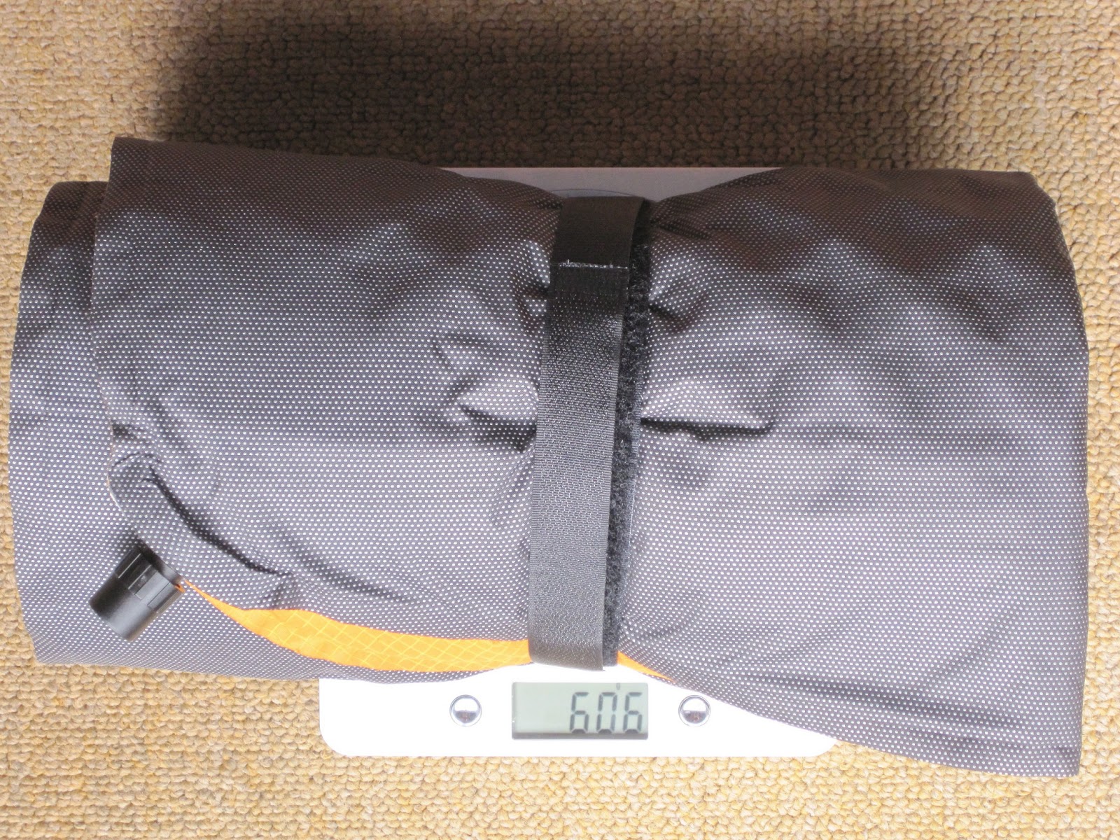
And the real tell - the Zor comes in at 385g (8g velcro strap used in photo, claimed weight 405g), Prolite3 at 601g (5g velcro strap used in photo, claimed weight 570g). The 5g strap came included with the Zor.
There is a newer version of the Prolite available at a claimed 460g but I figured that if I was bothering to change I may as well go for the biggest practical weight saving. I'm looking forward to my next camping trip (likely to be June now) to see how this mat works out.

Thursday, 28 March 2013

GAB Part Deux

The year started off well, putting the miles in. January started warm and turned wet. February was cold but the miles happened. March has been a write-off. Oh well...
The game is now back on working fitness up towards another leg of Glyde Around Britain - this time with Kate. I've only got a week off work so the plan is to get a lift down to Weymouth (where Part 1 ended) and pick up the coastal route towards Devon, Cornwall and back along the north coast to, perhaps Bristol or Chepstow... The route plan is keeping as coastal as practicable so I should get 500 miles or so in, hopefully with either time to grab some of the south coast of Wales, or to ride the extra 100miles back from Bristol to Derby.
And hopefully Kate will behave herself, unlike the Glyde last leg.